Map of the plan
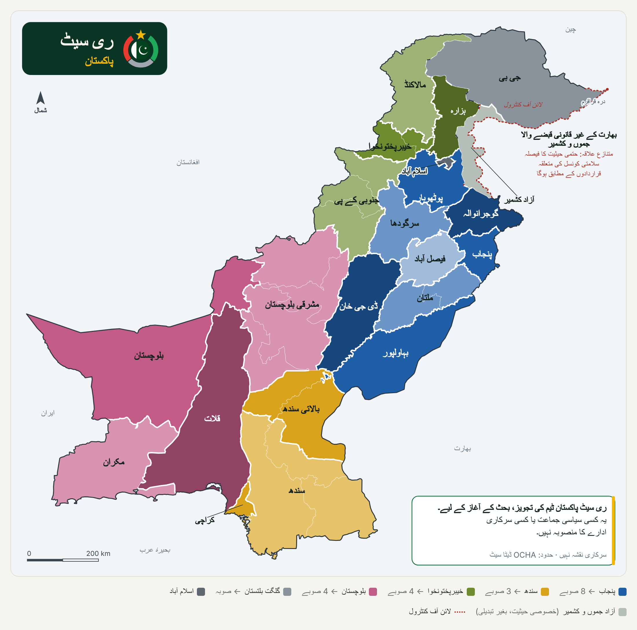
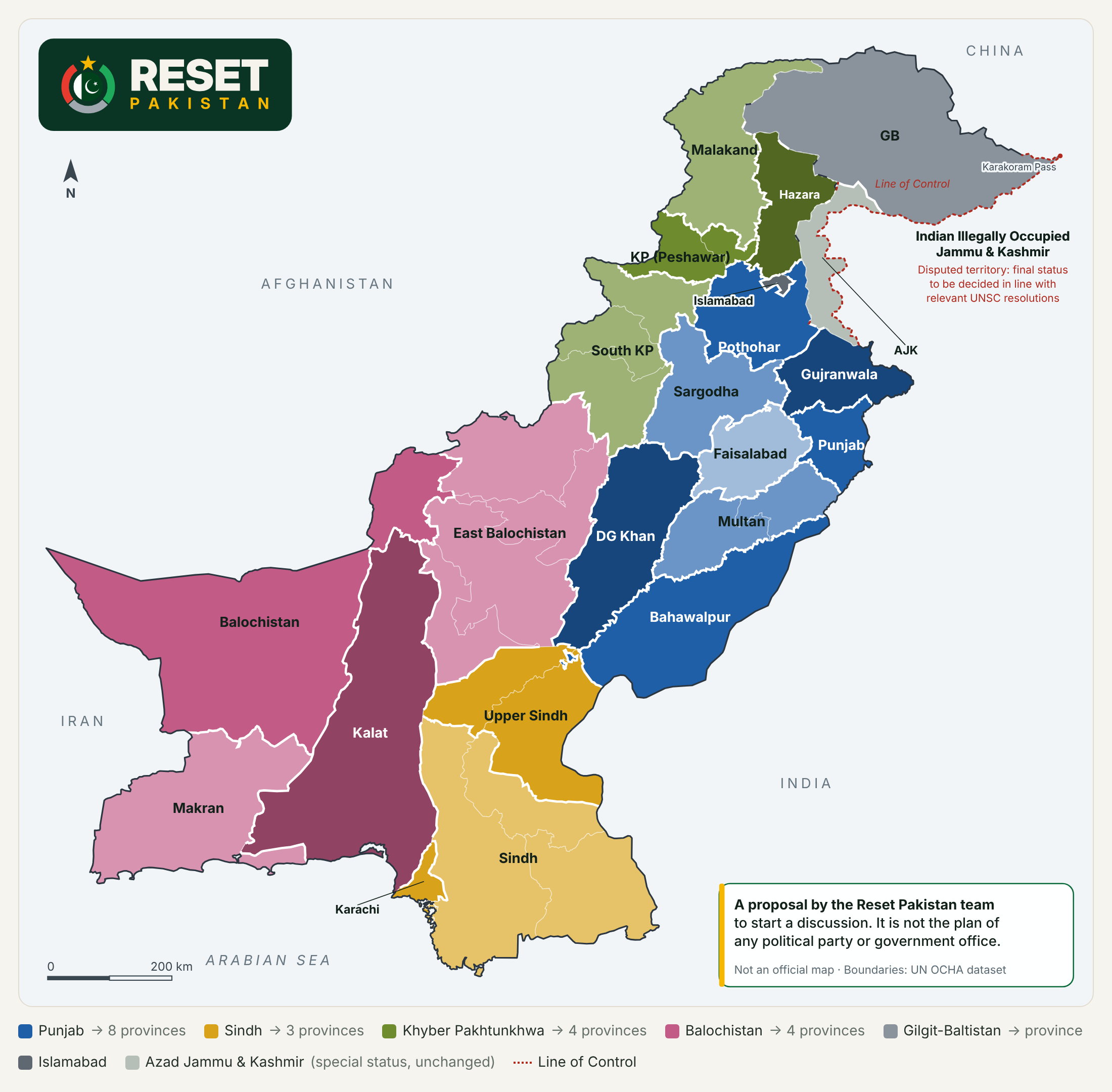
20 provinces made from today’s divisions, with the disclaimer on the map.
The plan
Government is close to citizens only if a province is small enough in people to listen and small enough in land to reach. Pakistan fails both tests: Punjab holds more than half the country, and Balochistan covers two-fifths of its land. This plan rebuilds the federation from existing divisions, and tests it against Pakistan’s own data, against economies of Pakistan’s size and against countries that have already redrawn their maps.
Disclaimer. This plan is a proposal by the Reset Pakistan team to start a public discussion. It is not the proposal of any political party or any government office.
Share of Pakistanis in the largest unit
Punjab today; Punjab (Lahore) under this plan
Land in the largest unit
Balochistan today; Balochistan (Quetta) under this plan
Units in the federation
20 provinces, Islamabad, and Azad Jammu and Kashmir with its special status
Estimated yearly running cost
15 new governments; 3.9–4.5% of the provinces’ tax share, about Rs 1,600 a person a year
Too many people. The 2023 census counted 241.5 million people.[1] Punjab alone has 127.7 million, more than all but twelve countries.[40] Its government in Lahore answers for villages hundreds of kilometres away; Hassan Baig, writing in The News, describes a six-hour drive from Rajanpur to Lahore to complete a government form.[38] A former Inspector General of Police, Afzal Ali Shigri, argues that large provinces keep power with a few cities and families.[39]
Too much land. Balochistan is 347,190 km², about 40% of the country, governed from one capital at its northern edge. Gwadar is about 900 km and 13 to 14 hours by road from Quetta.[21][22] A citizen of Makran or Chagai who needs the provincial government faces a longer journey than a citizen of Rajanpur. Bringing services close to people is a question of distance as much as of numbers.
Census 2023 (Gilgit-Baltistan: 2017). Lines mark our two tests: 25 million people and about 100,000 km².
People
Land, km²
Pakistan’s own statistics show what governing from far away costs. The first official measure of multidimensional poverty, published by the Ministry of Planning with UNDP in 2016, counted 39% of Pakistanis as poor in education, health and living standards. The best-off districts were Islamabad, Lahore and Karachi, each below 10%; the worst were Qila Abdullah, Harnai and Barkhan in Balochistan, each above 90%. In cities the rate was 9.3%; in villages, 54.6%.[48][49]
Share of people who are multidimensionally poor (education, health and living standards), 2014-15. The line marks the national rate, 39%.
Money follows the capital. Lahore district holds about a tenth of Punjab’s people. In the five years to FY18 it was allocated 19% of the province’s development budget and, by policy analyst Hasaan Khawar’s reading of the budget books, received half of what was actually spent: Rs 853 billion of Rs 1.7 trillion. Over the same years South Punjab lost about 43% of its allocation.[50] Planning officials told Dawn in 2016 that South Punjab is allocated 31 to 36% of the development budget but has historically received 17 to 20%.[51] The Punjab government disputes some of these estimates: in 2016 its finance minister said Lahore’s share of that year’s programme was 23%.[52] Even that is more than twice Lahore’s share of the population.
Lahore district’s share of Punjab, FY13 to FY18. The line marks its share of the population.
This does not prove that a smaller province will spend better. It shows that in a very large province the capital wins the argument over money, year after year. A province of its own gives Multan, Bahawalpur or Dera Ghazi Khan a budget that no one in Lahore can move.
We compared Pakistan with the 19 countries of the G20. Their states, provinces and regions are, at the median, 3.7 million people and 91,313 km² each. Pakistan’s units average 40 million people: only India and China come close. Our plan brings the average to 11.6 million people and 41,385 km², still large in people by G20 standards, but no longer an outlier.
Each dot is a G20 country: the average population and land of its states or provinces. Lines mark the G20 medians: 3.7 million people and 91,313 km² per unit.
| Country | First-level units | People per unit | km² per unit |
|---|---|---|---|
| Turkey | 81 provinces | 1.08M | 9,674 |
| Russia | 83 federal subjects | 1.75M | 206,003 |
| Argentina | 23 provinces + Buenos Aires city | 1.90M | 115,850 |
| Saudi Arabia | 13 provinces | 2.48M | 165,361 |
| Japan | 47 prefectures | 2.65M | 8,041 |
| Italy | 20 regions | 2.97M | 15,103 |
| Canada | 10 provinces + 3 territories | 3.02M | 768,052 |
| South Korea | 17 provinces and cities | 3.04M | 5,908 |
| Australia | 6 states + 2 territories | 3.31M | 967,652 |
| France | 18 regions | 3.69M | 35,767 |
| Mexico | 31 states + Mexico City | 4.05M | 61,387 |
| Germany | 16 states | 5.28M | 22,349 |
| United States | 50 states + DC | 6.73M | 186,766 |
| South Africa | 9 provinces | 7.02M | 135,454 |
| Indonesia | 38 provinces | 7.40M | 50,120 |
| Brazil | 26 states + federal district | 7.82M | 315,198 |
| United Kingdom | 4 nations | 17.17M | 61,094 |
| India | 28 states + 8 union territories | 39.95M | 91,313 |
| China | 31 mainland provinces, regions and municipalities | 45.89M | 309,579 |
| Pakistan today | 4 provinces + GB + Islamabad | 40.50M | 144,846 |
| Pakistan, this plan | 20 provinces + Islamabad | 11.57M | 41,385 |
The G20 also shows how countries decide where lines go. Six lessons shaped this plan:
Most G20 countries are much richer than Pakistan, so we also compared Pakistan with the nine economies closest to it in size: nominal GDP between about $385 billion and $575 billion in the IMF’s estimates for 2026, against Pakistan’s $450 billion.[47] At the median, their first-level units hold 4.2 million people. Pakistan’s hold 40.5 million. Only Bangladesh, at 21.4 million people per division, reaches even half of that, and Bangladesh has a sixth of Pakistan’s land.
The nine economies closest to Pakistan’s, by IMF 2026 nominal GDP. Lines mark their medians: 4.2 million people and 24,967 km² per unit.
People per unit
Land per unit, km²
| Country | GDP, US$ bn | First-level units | System | People per unit | km² per unit |
|---|---|---|---|---|---|
| Chile | 402 | 16 regions | unitary | 1.23M | 47,256 |
| Colombia | 573 | 32 departments + Bogotá | unitary | 1.59M | 34,512 |
| Malaysia | 547 | 13 states + 3 federal territories | federal | 2.20M | 20,664 |
| Vietnam | 542 | 34 provinces (merged from 63 in 2025) | unitary | 2.95M | 9,745 |
| Egypt | 443 | 27 governorates | unitary | 4.24M | 37,091 |
| Nigeria | 387 | 36 states + federal capital | federal | 6.16M | 24,967 |
| Philippines | 502 | 17 regions (82 provinces below them) | unitary | 6.76M | 17,647 |
| South Africa | 489 | 9 provinces | quasi-federal | 7.02M | 135,454 |
| Bangladesh | 506 | 8 divisions (64 districts below them) | unitary | 21.43M | 18,558 |
Several of these countries are unitary states, where a province is an arm of the central government rather than a government of its own, so the comparison is about how far government sits from the citizen, not about federalism. Under this plan, Pakistan’s average unit would still hold more people than any of them except Bangladesh.
Vietnam is the case critics cite. In July 2025 it merged its 63 provinces into 34 to cut costs, and its legislature approved cutting nearly 80,000 public-sector jobs.[64][65] Even after the merger, the average Vietnamese province has about 3 million people, a quarter of the average unit in this plan.
The fairest test of the idea is the record of countries that have created new provinces or states. It is good more often than not, but not always, and the failures teach as much as the successes.
Worked
12.3% vs 6.8%
Yearly growth from 2004-05, against Uttar Pradesh, the state it left.
Worked
124% → 194%
Income per head as a share of India’s average, 2010-11 to 2023-24.
Worked
Carved from a neglected north; among Brazil’s fastest-growing states after separation.
Worked
Self-government for the eastern Arctic, approved by plebiscite and set up with federal money.
Mixed
8.6% vs 7.6%
Faster than Madhya Pradesh, but not significantly so in a stricter statistical test.
Mixed
26 → 38
Provinces today. Poverty fell in some new regions; human-development gaps widened in others.
Did not work
6.3% vs 11.4%
Slower than Bihar, the state it left, held back by unstable politics and weak administration.
Went the other way
63 → 34
Provinces merged to cut costs, yet still about 3 million people each, a quarter of this plan’s average.
India, 2000. India carved Uttarakhand out of Uttar Pradesh, Chhattisgarh out of Madhya Pradesh and Jharkhand out of Bihar. Using Planning Commission data, IndiaSpend found that from 2004-05 Uttarakhand’s economy grew 12.3% a year against Uttar Pradesh’s 6.8%, and Chhattisgarh’s 8.6% against Madhya Pradesh’s 7.6%, although Chhattisgarh had grown more slowly than its parent before the split. Jharkhand is the exception: it grew 6.3% while Bihar grew 11.4%.[53] Business Today reported that growth in the three new states rose by 4 to 6 percentage points after reorganisation, against about 2 points for India as a whole.[55] A stricter 2022 study at the Indira Gandhi Institute of Development Research, which compared each state with a statistical counterfactual, found clearly faster growth only in Uttarakhand, and concluded that smaller states do not solve economic problems on their own.[54]
How many times income per head multiplied between 2000-01 and 2010-11, in current rupees.
| State | Growth before (1994-95 to 2001-02) | Growth after (from 2004-05) |
|---|---|---|
| Uttarakhand | 4.6% | 12.3% |
| Uttar Pradesh | 4.0% | 6.8% |
| Chhattisgarh | 3.1% | 8.6% |
| Madhya Pradesh | 4.7% | 7.6% |
| Jharkhand | 3.6% | 6.3% |
| Bihar | 4.9% | 11.4% |
Telangana, 2014. India’s youngest state separated from Andhra Pradesh in 2014. A paper by the Economic Advisory Council to India’s Prime Minister puts Telangana’s income per head at 124% of the national average in 2010-11 and 194% in 2023-24, the second highest among Indian states.[56] Telangana Today reports average growth of 12.7% a year from 2014 to 2023, against India’s 10.5%.[57] Telangana had a head start most new provinces would not: it contains Hyderabad, one of India’s technology centres.
Brazil, 1988. Tocantins was created from the northern part of Goiás, whose people had long complained that a distant state capital neglected them. It became one of Brazil’s fastest-growing states,[58] and a study comparing it with similar regions found better economic and social indicators after separation.[59]
Canada, 1999. Nunavut was split from the Northwest Territories after a plebiscite, so that the Inuit of the eastern Arctic could govern themselves from Iqaluit instead of Yellowknife.[14] On its twentieth anniversary its premier said the territory had brought government closer to its people.[60]
Indonesia, since 1999. Indonesia has grown from 26 provinces in 1999 to 38 today and has created many new districts. The results are mixed. One study found the splits associated with wider gaps in human development;[61] another, by the national planning agency, found that poverty fell after North Kalimantan became a province in 2012;[62] and critics of the 2022 division of Papua saw it as a decision imposed from Jakarta.[20][63]
The lesson
Where new states did well, they had stable governments and capable administrations that spent their new budgets close to home. Where they did badly, as in Jharkhand, unstable politics and weak administration wasted the chance.[16] The lesson for Pakistan is that new provinces must come with the lean rules, local governments and civil-service reform set out on this site, and with the consent of the people concerned.
The case in brief. Each reason links to its evidence.
Gwadar is about 900 km and 13 to 14 hours by road from Quetta.[21][22] When France drew its departments in 1790, it made sure every settlement could reach its capital within a day.[10] No unit in this plan is larger than about 113,000 km².
Punjab holds 52.6% of Pakistanis today. The largest unit in this plan holds 9.4%.[1]
On one analyst’s count, Lahore, with a tenth of Punjab’s people, received half its development spending from FY13 to FY18, and South Punjab lost 43% of its allocation.[50]
Multidimensional poverty was under 10% in Islamabad, Lahore and Karachi and above 90% in three districts of Balochistan.[48]
The nine economies closest to Pakistan’s have a median of 4.2 million people per unit. Pakistan has 40.5 million.[47][7]
Uttarakhand, Telangana and Tocantins all grew faster than the regions they left. Not every split succeeds, which is why the design matters.[53][56][58]
About Rs 1,600 per citizen a year, 3.9 to 4.5% of the provinces’ tax share, on PRIME’s cost figures.[30]
Punjab created 385 posts and approved Rs 4 billion for a South Punjab secretariat that has no constitutional standing.[34][35]
Today one province elects 141 of the National Assembly’s 266 general seats, a majority on its own. Under this plan the largest unit elects 25.[66]
Every unit in this plan has fewer people per provincial assembly seat than its parent province has today.
A 2026 survey of 5,000 adults by Meridian Analytics found 77% support for more provinces.[40]
Article 239(4) allows new provinces with two-thirds of Parliament and of the province concerned, and the Punjab and Khyber Pakhtunkhwa assemblies have already passed resolutions for new provinces.[37][27][28]
Applied to Pakistan’s existing divisions, these tests produce 22 units: 20 provinces, Islamabad, and Azad Jammu and Kashmir with its special status. Three new provinces, Hazara, Kalat and Makran, pass the people, land and fit tests but not the cost test, and so does Gilgit-Baltistan, which is federally funded. They are kept for reasons of distance and identity, and adopt the small-province rules set out below.
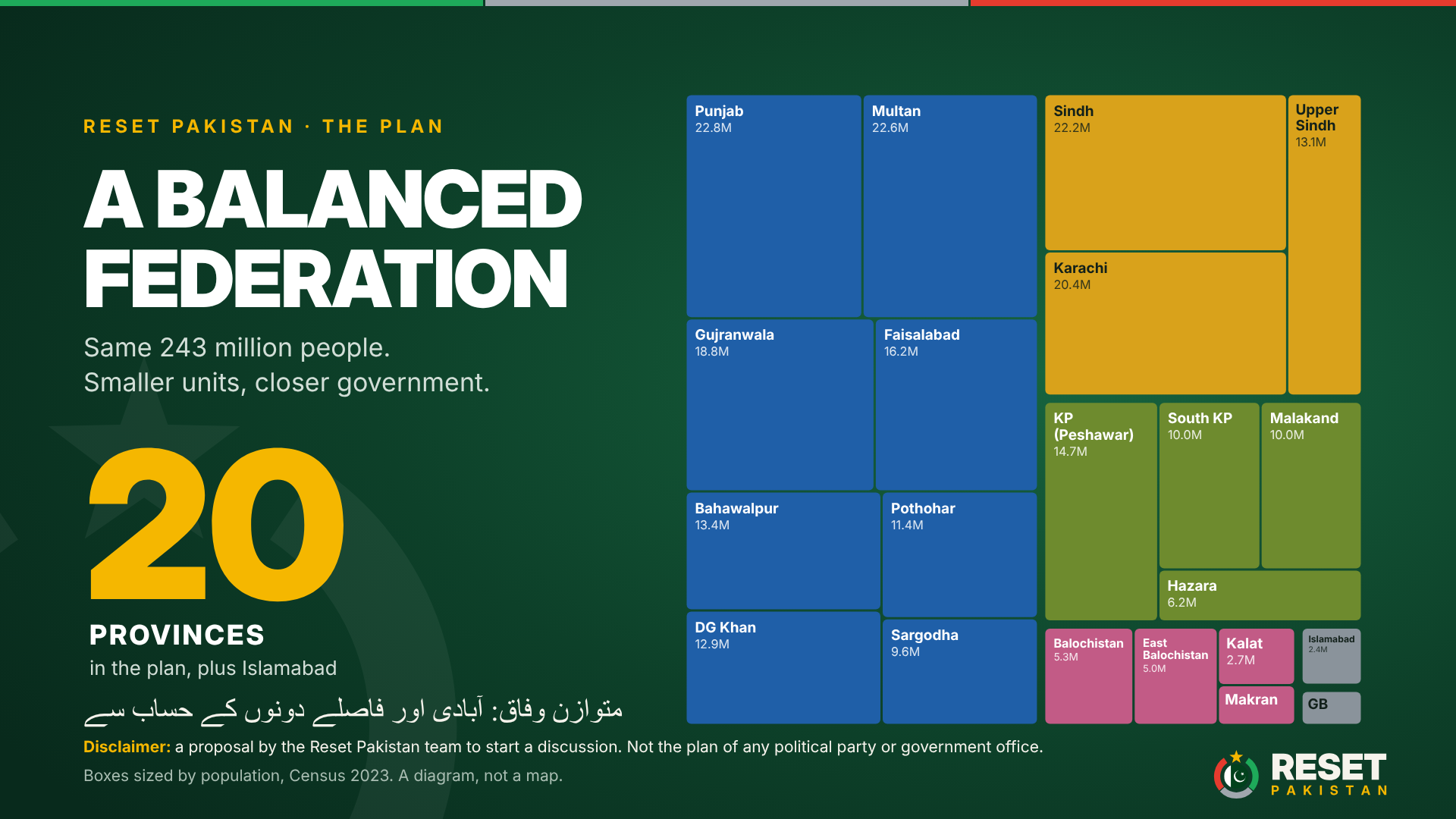
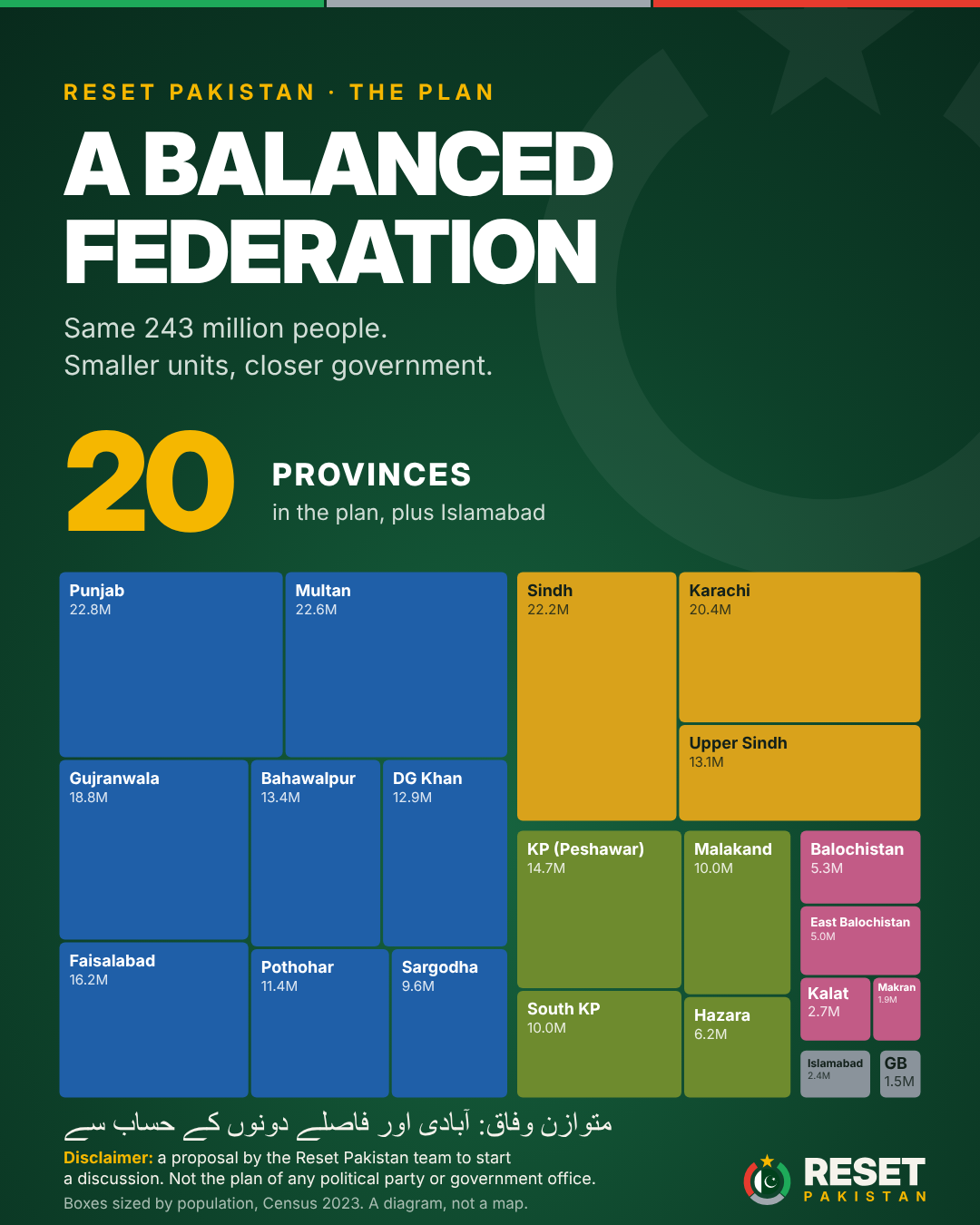
Eight provinces from today’s Punjab, three from Sindh, four from Khyber Pakhtunkhwa and four from Balochistan, with Gilgit-Baltistan as the twentieth. Each starts with a working name taken from its region or capital; its own assembly may adopt a heritage name instead.
Disclaimer. This plan is a proposal by the Reset Pakistan team to start a public discussion. It is not the proposal of any political party or any government office.
Download this map: English (PNG) · Urdu (PNG)
| # | Province (working name) | Heritage name option | Capital | Made of | Population 2023 | Area km² | Share | Running cost as % of transfers |
|---|---|---|---|---|---|---|---|---|
| From today’s Punjab | ||||||||
| 1 | Punjab | Lahore | Lahore | Lahore division | 22,772,710 | 11,727 | 9.4% | 2.8–3.2% (continuing government) |
| 2 | Pothohar | — | Rawalpindi | Rawalpindi division | 11,406,496 | 22,255 | 4.7% | 5.6–6.5% |
| 3 | Sargodha | Thal | Sargodha | Sargodha division | 9,591,275 | 26,360 | 3.9% | 6.7–7.7% |
| 4 | Gujranwala | Chenab | Gujranwala | Gujranwala and Gujrat divisions | 18,778,868 | 17,217 | 7.7% | 3.4–3.9% |
| 5 | Faisalabad | Sandal Bar | Faisalabad | Faisalabad division | 16,228,526 | 17,918 | 6.7% | 3.9–4.6% |
| 6 | Multan | — | Multan | Multan and Sahiwal divisions | 22,618,573 | 25,513 | 9.3% | 2.8–3.3% |
| 7 | Bahawalpur | — | Bahawalpur | Bahawalpur division | 13,400,009 | 45,588 | 5.5% | 4.8–5.5% |
| 8 | Dera Ghazi Khan | Dera Jat | Dera Ghazi Khan | Dera Ghazi Khan division | 12,892,465 | 38,778 | 5.3% | 5.0–5.7% |
| From today’s Sindh | ||||||||
| 9 | Karachi | — | Karachi | Karachi division | 20,382,881 | 3,527 | 8.4% | 2.9–3.3% |
| 10 | Sindh | Lar | Hyderabad | Hyderabad, Shaheed Benazirabad and Mirpurkhas divisions | 22,209,519 | 95,016 | 9.1% | 2.6–3.1% (continuing government) |
| 11 | Upper Sindh | Siro | Sukkur | Sukkur and Larkana divisions | 13,103,747 | 42,371 | 5.4% | 4.5–5.2% |
| From today’s Khyber Pakhtunkhwa | ||||||||
| 12 | Khyber Pakhtunkhwa | — | Peshawar | Peshawar and Mardan divisions | 14,674,669 | 12,309 | 6.0% | 4.9–5.7% (continuing government) |
| 13 | Malakand | — | Saidu Sharif | Malakand division | 9,959,399 | 31,162 | 4.1% | 7.3–8.4% |
| 14 | Hazara | — | Abbottabad | Hazara division | 6,188,736 | 17,064 | 2.5% | 11.7–13.5% above 10%: small-province rules |
| 15 | South Khyber Pakhtunkhwa | — | Dera Ismail Khan | Dera Ismail Khan, Bannu and Kohat divisions | 10,033,293 | 41,206 | 4.1% | 7.2–8.3% |
| From today’s Balochistan | ||||||||
| 16 | Balochistan | — | Quetta | Quetta and Rakhshan divisions | 5,299,164 | 113,155 | 2.2% | 8.0–9.3% (continuing government) |
| 17 | East Balochistan | — | Sibi | Zhob, Loralai, Sibi and Nasirabad divisions | 4,998,348 | 90,201 | 2.1% | 8.5–9.8% |
| 18 | Kalat | — | Khuzdar | Kalat division | 2,721,018 | 91,767 | 1.1% | 15.6–18.1% above 10%: small-province rules |
| 19 | Makran | — | Turbat | Makran division | 1,875,872 | 52,067 | 0.8% | 22.6–26.2% above 10%: small-province rules |
| From today’s Gilgit-Baltistan | ||||||||
| 20 | Gilgit-Baltistan | — | Gilgit | All districts of Gilgit-Baltistan (2017 census) | 1,492,924 | 72,971 | 0.6% | Federally funded; small-province rules |
| From today’s Islamabad | ||||||||
| 21 | Islamabad Capital Territory | — | Islamabad | Islamabad Capital Territory, special status (boundary under review) | 2,363,863 | 906 | 1.0% | — |
| 22 | Azad Jammu and Kashmir | — | Muzaffarabad | Keeps its present special status and its own government. Not part of the census figures above. | ||||
| Total, 21 units with census figures | 242,992,355 | 869,078 | 100% | |||||
20 provinces and Islamabad Capital Territory, grouped by the province they come from. Lines mark 25 million people and 100,000 km².
People
Land, km²
Diagram, not a map: boxes show population, not land or boundaries.
Keeping Balochistan whole would leave two-fifths of Pakistan governed from Quetta. Any division into three would leave at least one unit larger than 115,000 km², beyond the land test. We propose four provinces, each about 113,000 km² or less:
Kalat and Makran cannot pay for full provincial governments from their own share of federal taxes. On PRIME’s figures their running costs would be about 16 to 18% and 23 to 26% of their transfers. They would adopt the small-province rules below and receive a federal distance grant, as Canada funded Nunavut’s creation.[14]
We also know that Balochistan’s political parties reject new provinces, warning that the real aim is control of the province’s resources.[43][44] That fear has to be answered in the Constitution, not in speeches. Article 161 pays gas royalties and excise to the province where the well-head sits.[23] Divided, the royalties would follow wherever each field happens to lie. We propose a Balochistan Resource Compact in the same amendment: royalties and excise from every field in today’s Balochistan go into a common fund shared by its four successor provinces, so the resources stay with the people of Balochistan as a whole. And because Article 239(4) requires the consent of two-thirds of the Balochistan Assembly, none of this can happen unless Balochistan’s own representatives agree.
On 15 November 2026 several papers reported a federal plan to give Islamabad a special administrative status under a mayor with an elected body of 25 to 30 members, and to consider moving parts of Haripur district, some areas of Rawalpindi and localities in the NA-51 constituency of Murree into the capital.[25][26] The exact areas have not been published. The table takes the largest version that fits the reports.[6][5][2]
| Area | Population 2023 | Area km² | Moves from |
|---|---|---|---|
| Islamabad Capital Territory today | 2,363,863 | 906 | — |
| Rawalpindi tehsil | 3,744,590 | 1,682 | Pothohar |
| Murree district (NA-51 area) | 372,947 | 738 | Pothohar |
| Haripur district | 1,174,783 | 1,725 | Hazara |
| Largest version | 7,656,183 | 5,051 |
In that version Islamabad would grow from 2.4 million people to 7.7 million, Pothohar would fall from 11.4 million to 7.3 million, and Hazara from 6.2 million to 5.0 million. A capital region of more than seven million people needs a real elected government, not only a mayor and 25 to 30 members. And Hazara, already the smallest new province in Khyber Pakhtunkhwa, would depend even more on the small-province rules.
The National Assembly keeps its 336 seats; the 266 general seats are shared by population across the 21 units, and Gilgit-Baltistan, which has none today, gets two. Provincial assemblies get 15 general seats plus one for every 500,000 people, with no assembly smaller than Gilgit-Baltistan’s present 33. That gives 1,013 provincial legislators against 782 today,[33] but every unit ends up with fewer people per seat than its parent province has now.
The Senate keeps equal representation: 7 seats per province and Islamabad’s 4, a house of 144 against 96 today. Keeping today’s 23 seats per province for 20 provinces would mean a Senate of 464.
| Unit | National Assembly | Provincial assembly | Senate | ||||||
|---|---|---|---|---|---|---|---|---|---|
| General | Women | Total | General | Women | Non-Muslim | Total | Cabinet cap | Seats | |
| Punjab | 25 | 6 | 31 | 61 | 14 | 2 | 77 | 8 | 7 |
| Pothohar | 12 | 3 | 15 | 38 | 8 | 2 | 48 | 5 | 7 |
| Sargodha | 10 | 2 | 12 | 34 | 8 | 1 | 43 | 5 | 7 |
| Gujranwala | 21 | 5 | 26 | 53 | 12 | 2 | 67 | 7 | 7 |
| Faisalabad | 18 | 4 | 22 | 47 | 10 | 2 | 59 | 6 | 7 |
| Multan | 25 | 6 | 31 | 60 | 13 | 2 | 75 | 8 | 7 |
| Bahawalpur | 15 | 3 | 18 | 42 | 9 | 2 | 53 | 5 | 7 |
| Dera Ghazi Khan | 14 | 3 | 17 | 41 | 9 | 2 | 52 | 5 | 7 |
| Karachi | 22 | 5 | 27 | 56 | 12 | 2 | 70 | 7 | 7 |
| Sindh | 24 | 6 | 30 | 59 | 13 | 2 | 74 | 8 | 7 |
| Upper Sindh | 14 | 3 | 17 | 41 | 9 | 2 | 52 | 5 | 7 |
| Khyber Pakhtunkhwa | 16 | 4 | 20 | 44 | 10 | 2 | 56 | 6 | 7 |
| Malakand | 11 | 2 | 13 | 35 | 8 | 1 | 44 | 5 | 7 |
| Hazara | 7 | 2 | 9 | 27 | 6 | 1 | 34 | 5 | 7 |
| South Khyber Pakhtunkhwa | 11 | 3 | 14 | 35 | 8 | 1 | 44 | 5 | 7 |
| Balochistan | 6 | 1 | 7 | 26 | 6 | 1 | 33 | 5 | 7 |
| East Balochistan | 5 | 1 | 6 | 26 | 6 | 1 | 33 | 5 | 7 |
| Kalat | 3 | 1 | 4 | 26 | 6 | 1 | 33 | 5 | 7 |
| Makran | 2 | 0 | 2 | 26 | 6 | 1 | 33 | 5 | 7 |
| Gilgit-Baltistan | 2 | 0 | 2 | 26 | 6 | 1 | 33 | 5 | 7 |
| Islamabad Capital Territory | 3 | 0 | 3 | — | — | — | — | — | 4 |
| Total | 266 | 60 | 326 | 803 | 179 | 31 | 1013 | 115 | 144 |
The strongest practical objection is cost: more governors, chief ministers, cabinets, assemblies, secretariats, courts, cars and protocol. Sindh’s local government minister, Syed Nasir Hussain Shah, says the economy cannot bear it.[29] The Policy Research Institute of Market Economy (PRIME) puts the yearly cost of one new province’s core institutions at Rs 22.4 to 25.9 billion, a lower bound that leaves out buildings and police headquarters.[30]
This plan creates 15 new provincial governments. On PRIME’s figures that is Rs 336–388bn a year before any savings: 3.9 to 4.5% of the provinces’ Rs 8.64 trillion tax share this year,[29] or about Rs 1,600 per citizen. It costs about half as much as making every division a province, and about Rs 160 to 180 billion a year more than the 12-province formula under discussion. What that buys is a federation in which no unit is too big to listen or too far to reach.
Recurring cost of core institutions (governor, chief minister, assembly, secretariat, High Court), billions of rupees a year. Dark: low estimate. Light: high estimate.
Most new provinces pass PRIME’s 10% screen, at 3 to 10%. Four do not: Hazara (about 12 to 14%), Kalat (16 to 18%), Makran (23 to 26%) and Gilgit-Baltistan, which is federally funded. They are needed for reasons of distance and identity, so instead of dropping them we give them lighter institutions.
Our proposals
Cost has another side. Punjab already pays for half a province: in 2020 it created 385 posts for a South Punjab Secretariat and approved Rs 4 billion for buildings and residences in Multan and Bahawalpur, and without constitutional status those powers could later be pulled back to Lahore.[34][35][36] Paying for a province without giving it a government is the most expensive option of all.
Changing a province’s limits needs a constitutional amendment passed by two-thirds of each house of Parliament and two-thirds of the assembly of the province concerned, under Article 239(4).[37] A referendum can show public opinion, but legal experts say it would not bind the government and cannot replace that process.[29] Germany goes further and requires a referendum in the areas affected;[12] we think Pakistan should hold local votes too.
The other side
Maps
The map of today’s provinces and the map of the plan are drawn from the UN OCHA boundary dataset for Pakistan.[68] We checked its boundaries of Azad Jammu and Kashmir and Gilgit-Baltistan against the Survey of Pakistan’s official Political Map of Pakistan (2020): at that map’s 1:3,000,000 scale, the Line of Control and the line from its northern end to the Karakoram Pass follow the official map. As on the official map, Indian Illegally Occupied Jammu & Kashmir is marked as disputed territory.[70]
The proposed provinces are existing divisions joined whole, so no new line is drawn inside today’s provinces. They are a proposal for discussion, not an official map, and they have not been vetted by the Survey of Pakistan. Pakistan’s Surveying and Mapping (Amendment) Act, 2020 bars printing or displaying an incorrect and unofficial map of Pakistan, with penalties of up to five years in prison, a Rs 5 million fine, or both, and asks that maps be vetted by the Survey of Pakistan before publication.[67][69] If you find an error in these maps, tell us and we will correct it.
This outline is a starting point for a national conversation, not a decree. A federation sized for both its people and its land, built from divisions people already know, with costs published and powers passed down to local government, can bring government within reach of every citizen, in Rajanpur and in Gwadar alike. Tell us where we are wrong.
Free to share with credit to Reset Pakistan. Please keep the disclaimer: this is a proposal by the Reset Pakistan team to start a discussion, not the plan of any political party or government office.